Today I did some hiking in Little Pine State Park. This was the first time I’ve been to this state park even though it is located in Lycoming County. I saw Little Pine Creek Road when I went hiking on the Golden Eagle Trail which is technically in Tiadaghton State Forest. Little Pine State Park is just a 30 minute drive from where I live. I picked up a map to the Little Pine State Park at the Lycoming County Visitor Center which is located across from Wegmans. They had maps for all the area state parks and a travel guide for Tioga County which will be useful. I’ll have to stop in again for another Little Pine State Park map since I kept the first map in my shirt pocket and it got soaked with sweat.
A dam on Pine Creek has created a small lake and the park surrounds the lake. Forested mountains surround the lake making for a very picturesque scene. Little Pine State Park with its lake is comparable to the many outdoor recreation areas in the Poconos which surround lakes. But unlike the Poconos this state park and lake is not crowded with tourists. I only saw a few boats out on the lake and I only encountered a few other hikers on the trails. Since Lycoming County is too far west for New Yorkers and Philadelphia residents you are not going to get the large number of tourists.
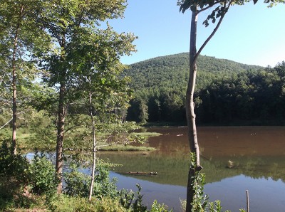
Little Pine State Park
I only hiked two trails because the trails are long and difficult. It is hard to tell which trail I hiked because the trail sign read “Love Run Trail” but I think that was the road while the trail was the Panther Run Trail. The trail was blazed with yellow rectangles. I found the trailhead across from the Eagle Watch Area which is further up the road from Pavilion 3. The trail began with a very steep ascent. Unfortunately hiking in Pennsylvania frequently requires climbing up a hill. Fortunately I had my hiking poles which are great for climbing uphill or downhill. I was also wearing my new hiking boots which are waterproof. It seemed like I climbed uphill forever but eventually the trail leveled off and followed a mountain ridge. The path along the ridge was covered in moss and led through numerous rock outcroppings. I was surprised by the number of large rock outcroppings. One rock outcropping had a keyhole through which you could see the forested mountains. I took a lot of photos of the keyhole hoping to get a great shot but the sunlight seemed to be causing glare no matter how I took the picture. It looks like I got one good photo through the keyhole but the mountains in the background are lost in the glare.
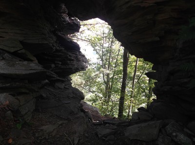
Keyhole
Eventually the trail along the ridge came to a dead end at a clearing. There may have been a way to go further but it looked ridiculously steep so I retraced my steps going back down the mountain. Going downhill can be just as difficult as climbing uphill, just not so tiring. My toes were being mashed in the toe of my boots as I walked downhill. I was wearing two pairs of padded socks so it wasn’t too bad. There really wasn’t any vistas on that trail because the trees were in the way but you could see some mountains through the trees.
The first trail was so exhausting that I almost called it a day. I drove back to Waterville, the small village on Route 44 right where Little Pine Creek Road begins. I stopped in for lunch at the Waterville Tavern. There were a lot of bikers at the Waterville Tavern. I saw way more motorcycles than cars in the parking lot. I suspect bikers like the scenic drive along the Pine Creek Gorge. The Waterville Tavern is perfectly situated for visitors to the Little Pine State Park since it is right across from the access road. They have a black bear on their logo and the pine wood interior makes the place seem woodsy. I ordered a Coke and a chicken sandwich with hot barbeque sauce which came with chips and a sliver of pickle. For dessert I had ice cream with funnel cake sticks. The meal was pretty good and only cost me $22.00 including tip. That was my only expense for the day.
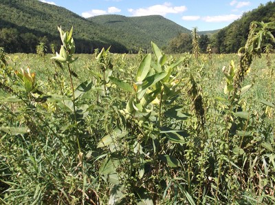
Little Pine State Park Valley Fields
After lunch I wasn’t so hot and thirsty so I decided to hike another trail at Little Pine State Park. It was a short drive back to park but this time I parked near the dam. I hiked the Lake Shore Trail. This trail starts off with an easy trail along an access road but it does climb a little to run above the lake. You don’t get any really good views of the lake through all the trees. Eventually this trail forms a huge loop pass the lake. The Lake Shore Trail Loop takes you into a vast valley with the trail going through the fields. I thought this was the best scenery in the park since it seemed like virgin wilderness. There was a tall stand of pine trees in the middle of a swampy area which looked particularly dramatic. Unfortunately this was very long and tiring trail out in the middle of nowhere so it seemed to go on for entirely too long. The hike back was partially uphill so that was very tiring too. The Lake Shore Trail is a bit of an ordeal if you do the entire trail.
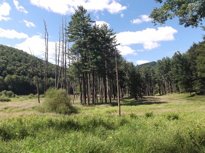
Tall Pine Trees
Next week I’m going on the Tioga Central Railroad Dinner excursion train. I don’t think the train goes along the Pine Creek Gorge but it goes through similar terrain. It will be nice to ride through the woods and countryside in comfort instead of hiking though it.

